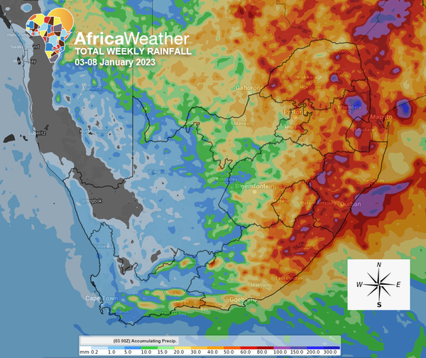
South Africa: Inclement weather is highly anticipated on Thursday and Friday over the central and eastern parts, following a wet start in the west and central regions.
Yesterday, a flurry of storms descended upon the country’s central, southern and eastern parts in the afternoon. Today, a similar picture is about to be at play as a surface trough over the central parts, associated with an upper air counterpart, is expected to initiate scattered storms over the Cape interior, central parts and along the southern and eastern escarpment.
High chance of light rainfall across the areas mentioned above. High chance of strong NW to SW winds gusting at 40-50km/h over the western Northern Cape today.
On Wednesday, a cold front is expected to worsen the rainfall and thunderstorms situation. High chance of showers and thundershowers across almost the entire country, excluding eastern Limpopo and western Northern Cape. The central parts stand to receive the most rainfall, with a low chance of high-impact thunderstorms (with hail and strong winds) over the southern Karoo. High chance of strong SW winds gusting at 50km/h over the western Northern Cape.
The upper air trough catches up with the cold front extending the inclement weather period from Thursday into the later part of the week. High chance of light to moderate rainfall over most of the country except the north-western parts. Medium chance of intense rainfall exceeding 50mm over the eastern Eastern Cape, KwaZulu-Natal and central Mpumalanga.
Friday is the day the system moves east, allowing more of the west to clear out while the east receives somewhat continuous showers and thundershowers. Medium chance of excessive rainfall (above 50mm) in the far eastern Mpumalanga (near Hazyview and Mbombela) but low in Limpopo.
Throughout the weekend, calm and warm to hot weather will infiltrate more of the central and eastern interior but it will be cloudy in the east on Saturday at first and become sunnier on Sunday.