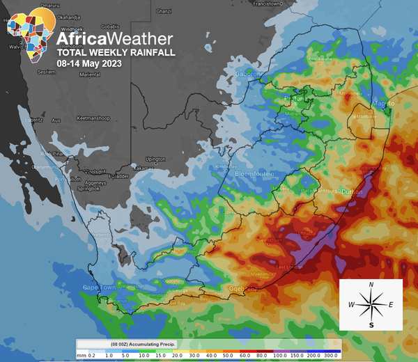
Africa: Africa Weather Forecast launched its weekly summary (08 May – 14 May 2023); as per African weather reports, Relentless rainfall is highly anticipated in places over the central and eastern provinces from an intensifying Cut-Off Low (COL) today and tomorrow (Tuesday).
Otherwise, calm skies are expected midweek over the west and central interior in anticipation of another cold front/COL arriving in the southwest on Friday.
There is a high chance of intermittent rainfall in places over the central and northeastern provinces today, with moderate to intense showers and thundershowers in Gauteng, eastern North West, southern Limpopo, east coast, eastern KwaZulu-Natal and eastern Mpumalanga.
On Tuesday and Wednesday, diminishing rainfall amounts are expected in the east as the COL moves northeast towards Botswana and Zimbabwe. And while persistently cloudy and cool conditions dominate the east, the west and some central parts will start warming up due to continuous clear skies.
By Thursday, a prefrontal trough is expected to bring light rainfall and cloudy conditions into the southern and western Western Cape. At the same time, the east starts showing signs of recovery from the recent precipitation and cloudy conditions.
On Friday, the cold front finally arrives in the west, bringing light rainfall into the southern Cape but moderate along the south coast, strong NW winds over the Cape interior and light snowfall along the southern peaks of the Drakensberg mountains. At the same time, fine and warm to hot weather persists over the central interior and spreads into the northeastern regions. It will be partly cloudy with morning fog patches in the Lowveld.
The most recent models suggest intensifying this cold front with upper-air support, transforming it into a Cut-Off Low. Strong, cold-cored cyclonic activity in the southwest points to a high chance of moderate rainfall over the Cape interior, possibly resulting in flash floods in the southeast, snowfall over the Eastern Cape mountains, and strong winds southerly winds gusting at 40-50km/h over the southern Cape but north-westerly at 30-40km/h over eastern Highveld on Saturday.
By Sunday, the system will have shifted east, as will most showers. High chance of light rainfall in the east, particularly the southeast, where rains may be moderate with south-westerly solid winds along the east coast.