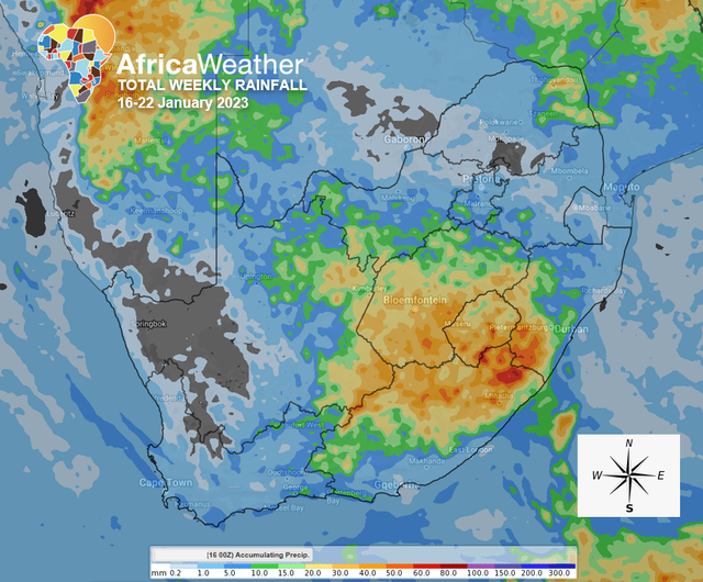
Africa: Africa Weather Forecast launched their weekly summary (16-22 Jan 2023). As per African weather reports, a few storms in the south in the first part of the week, followed by more intense showers over the central and eastern parts later in the week.
The high-pressure cell in the east has moved into the Indian Ocean but will still have limited influence over the eastern regions, where it will continue suppressing thunderstorms in the first part of the week; however, there is a very low chance of isolated thunderstorms in places in the east during this first part of the week.
This morning’s storms in the far south near Gqeberha and in the far north near Musina are slowly moving east with a high chance of scattered thunderstorms over the Eastern Cape, isolated over southern Free State, eastern Western Cape and southern Northern Cape this afternoon.
Strong NW winds over the central and southern Northern Cape today, compounded by intense heat, will most likely result in a high risk of veld fires today and Tuesday, becoming less intense midweek and towards the later part due to extended rainfall.
Tuesday and Wednesday will most likely have the same repetitive weather patterns, a high chance of light morning showers over Limpopo and the northeast, and isolated thunderstorms over the southern Cape.
Showers will most probably spread into the rest of the Cape interior while persisting over the Eastern Cape on both Tuesday and Wednesday.
Later in the week, more tropical moisture will infiltrate the central parts of the country, resulting in widespread showers midweek, now covering more of the central and eastern interiors, but most importantly, spreading east into the rest of the Highveld from Thursday afternoon and into the rest of the week.
High chance of light to moderate rainfall from scattered showers and thundershowers over the central and eastern interior on Thursday and Friday. Very low chance of high-impact rainfall over the eastern Eastern Cape, central Free State and western KwaZulu-Natal on Friday.
There are signs showing an intensification of the system between Saturday and Sunday, resulting in widespread showers and thundershowers over the central and eastern interior, with moderate to intense showers over the central parts on Saturday but over the southeast on Sunday.
By Sunday, although the system will be moving away, its remnants will continue precipitating moderate showers over the central interior with partly cloudy skies elsewhere.